FRAME TIME
100%
© 2026 Orbital Overview
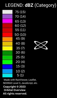
Orbital Overview's weather radar combines NOAA MRMS (Multi-Radar Multi-Sensor) precipitation data with real-time cloud-to-ground lightning strike detection — all in a single interactive map updated every two minutes.
Toggle the Lightning layer to see real-time strike locations across the contiguous United States. Each strike is plotted the moment it's detected and fades over time, giving you a running picture of electrical storm activity and lightning density near you.
MRMS fuses data from over 180 NEXRAD Doppler radars, surface weather stations, rain gauges, and satellite observations into a seamless, quality-controlled mosaic. The result is higher-resolution, more accurate precipitation mapping than any single radar site can provide.
Switch to the Satellite view for infrared cloud-top imagery. Colder (higher-altitude) cloud tops appear brighter, making it easy to spot developing thunderstorms, tropical systems, and large-scale weather patterns even at night.
Press Play to animate the last several radar frames and watch storms develop and move in real time. Step through frames manually with the forward and back controls to pinpoint exactly when precipitation or lightning arrived at a location.
Our lightning map displays real-time cloud-to-ground lightning strikes detected across the United States. Strikes are plotted as they occur and fade over time, giving you a live view of electrical storm activity.
The NOAA MRMS precipitation data updates approximately every 2 minutes, providing one of the fastest refresh rates available for public weather radar.
MRMS (Multi-Radar Multi-Sensor) combines data from 180+ NEXRAD radars, surface observations, and satellite data into a seamless high-resolution mosaic. It provides more accurate precipitation estimates and faster updates than a single NEXRAD site alone.
Yes. Enable the Lightning toggle on the radar, then click My Location to center the map on your position. You will see real-time lightning strikes plotted in your area as they are detected.
Lightning density shows the concentration of lightning strikes in a given area over a recent time window. Higher density indicates more intense electrical activity in a storm cell, which often correlates with severe weather including heavy rain, hail, and tornadoes.
Orbital Overview is built by Jesse E. Conner. Weather data is sourced from NOAA, the National Weather Service, and the National Lightning Detection Network. Explore more at OrbitalFusion or visit engineer.guide.